A tram line concept for Goldsboro
I didn’t grow up in Goldsboro. I was born here, the son of an airman stationed at Seymour Johnson Air Force Base. We left when I was four and I returned at 29. I stayed through the pandemic and it seems I will be here for the foreseeable future.
Goldsboro is working at revitalizing their downtown. The crown jewel of their efforts is Center Street, a divided two-lane street with parking on either side of each lane. The intersections on Center Street are roundabouts that house art installations. It’s beautiful, although roundabouts tend to be less friendly to pedestrians and this is meant to be a walkable street.
A few blocks away from Center Street sits the defunct Amtrak Station, which sits boarded up next to a gleaming new bus station. The city runs short buses—really more like shuttles. There’s been talk of renovating the Amtrak station but the state is currently more focused on a mountain-to-sea route and increasing frequency between Raleigh and Charlotte.
As a urban planning enthusiast, I have spent some time thinking about what might benefit this town of 33,000 and what I’d like to see here based on my experiences in other parts of the world—like the reinstalled streetcars in El Paso, Texas or the extensive tram lines of Melbourne, Australia. I have a few ideas, but this one is ready to share first.
Goldsboro has several streets that are five to six lanes wide. Some of them are part of US highway business routes. They cut through residential and commercial areas.
And they would be the perfect routes for tram lines.
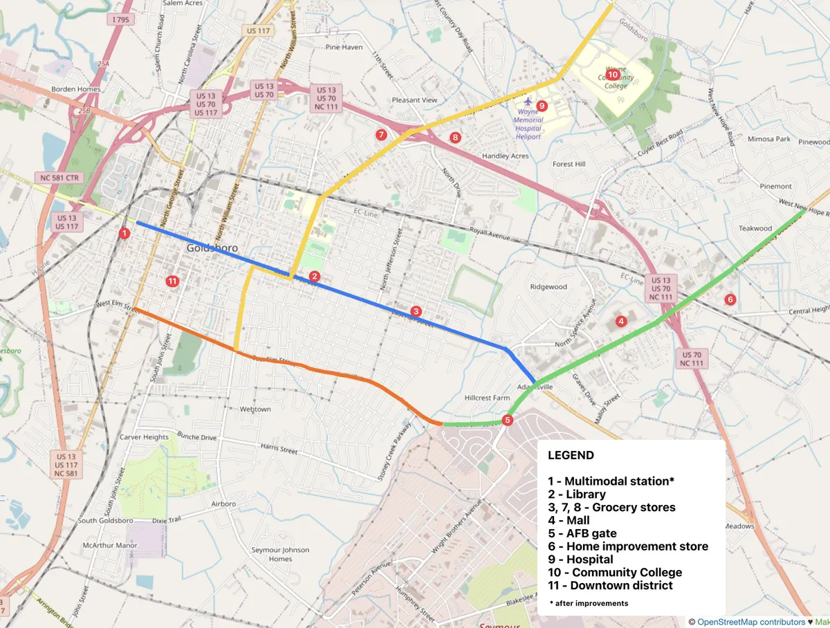
I prepared a rudimentary map of the town with four tram lines overlaid.
Blue runs along Ash Street from North Carolina St, where the multimodal station is located, to Berkeley Blvd. It connects the multimodal station, Center Street, the library, parks, grocery stores, and the Berkeley commercial district.
Green runs along Berkeley Blvd from New Hope Rd to Elm St, then along Elm to Hillcrest (this short leg is optional, but seems the easiest way to provide those on base with access to the tram). It connects the base, Berkeley commercial district, and residential areas near New Hope.
Yellow runs along Wayne Memorial Dr from New Hope to Ash, then jogs over to Slocumb St. It can later be extended further down Slocumb. It connects the convention center, community college, hospital, and Wayne Memorial commercial district to the older neighborhoods and the Blue route.
Orange runs along Elm St from Hillcrest Dr (or Berkeley) to George St. With cooperation from Wayne County Public Schools, it can be connected with the Blue line via North Carolina St. Some members of the town might consider this the seediest tram line as it runs through older, poorer neighborhoods.
I have listed these four routes in roughly the order I would develop them. Blue and Orange could combine into a loop, while Yellow and Green provide north-south access.
An additional route could be Royall, though it is bordered by the freight rail on one side and provides limited access to neighborhoods; and eventually New Hope, though it is a very low density area right now.
The lines as I recommend them provide transit that connects established neighborhoods, which may infuse them with new life (especially if zoning restrictions and parking minimums are lifted to allow small shops, accessory dwelling units, and other novel uses). They also connect those neighborhoods to existing commercial districts that I would like to see become more mixed use (that’s a later post).